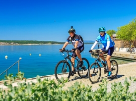
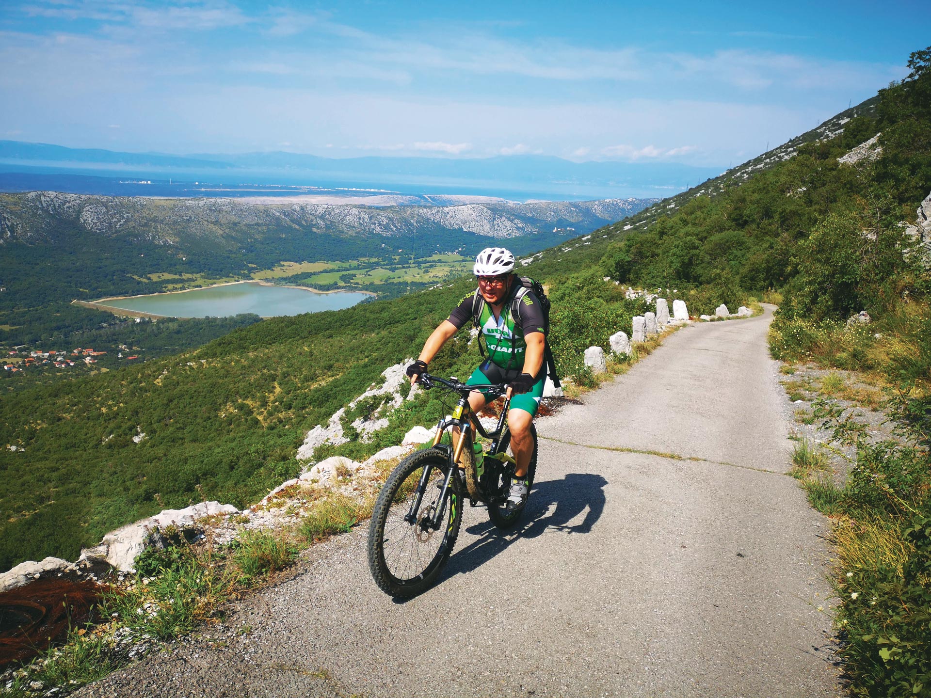
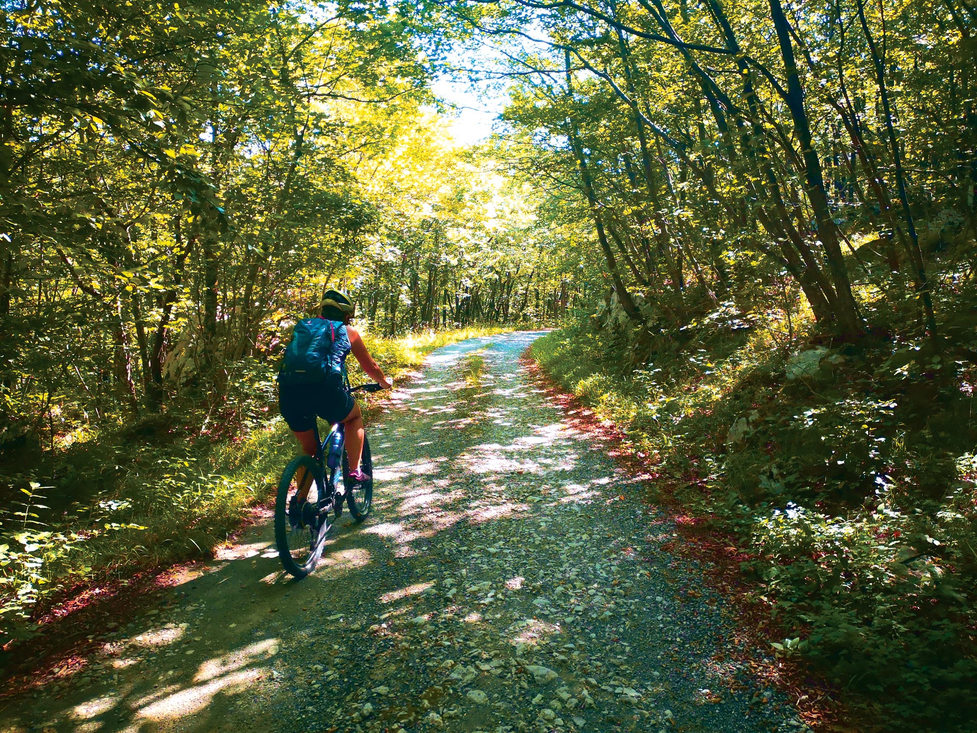
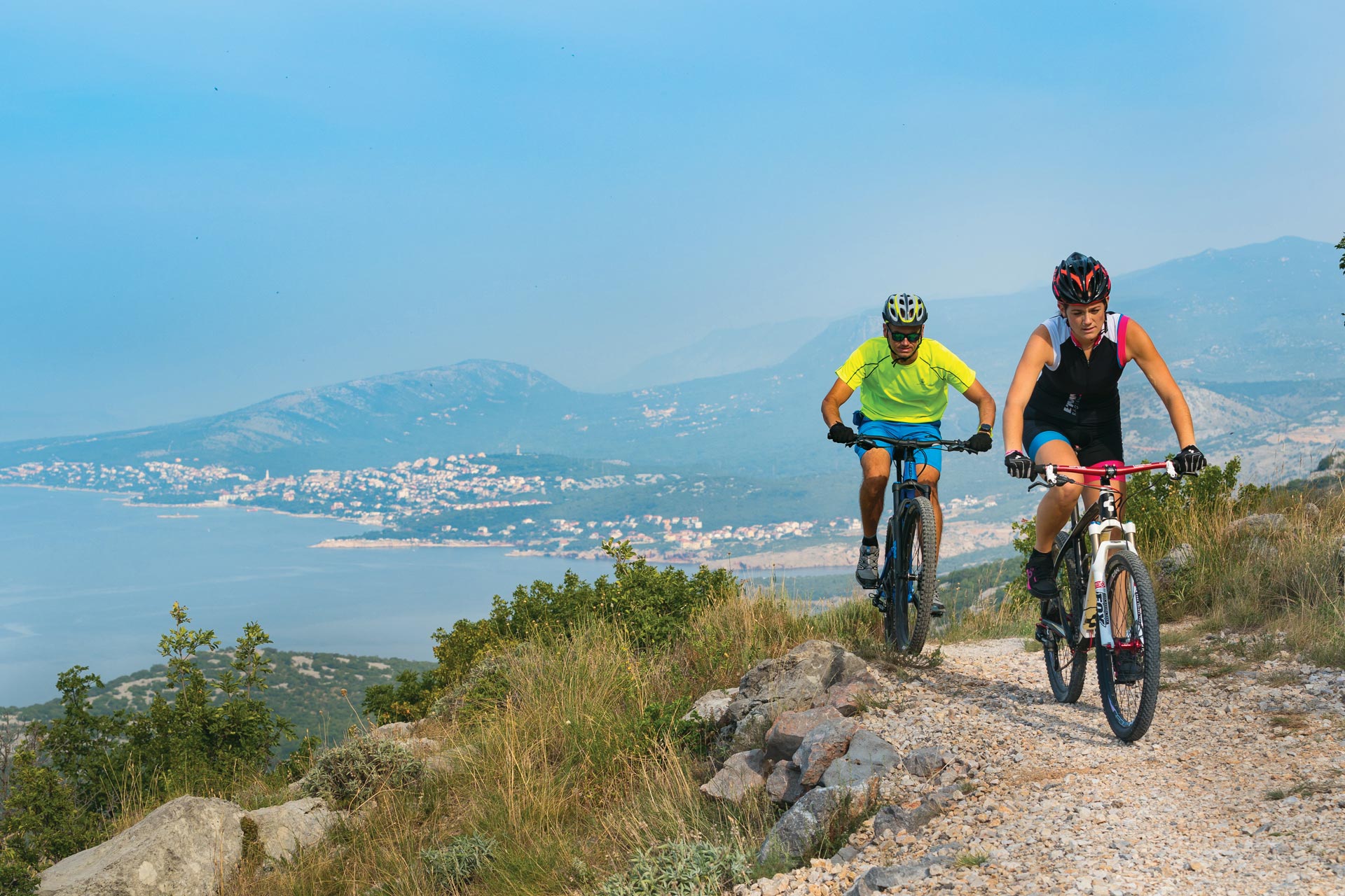
CYCLING
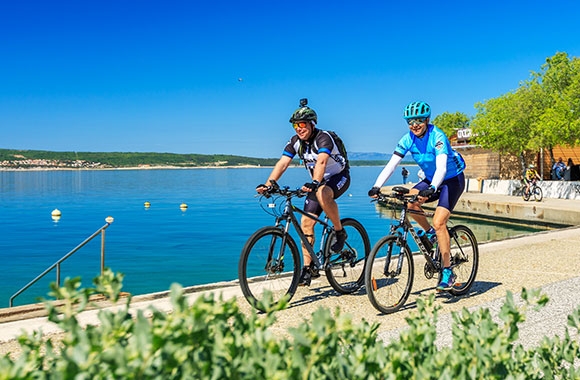
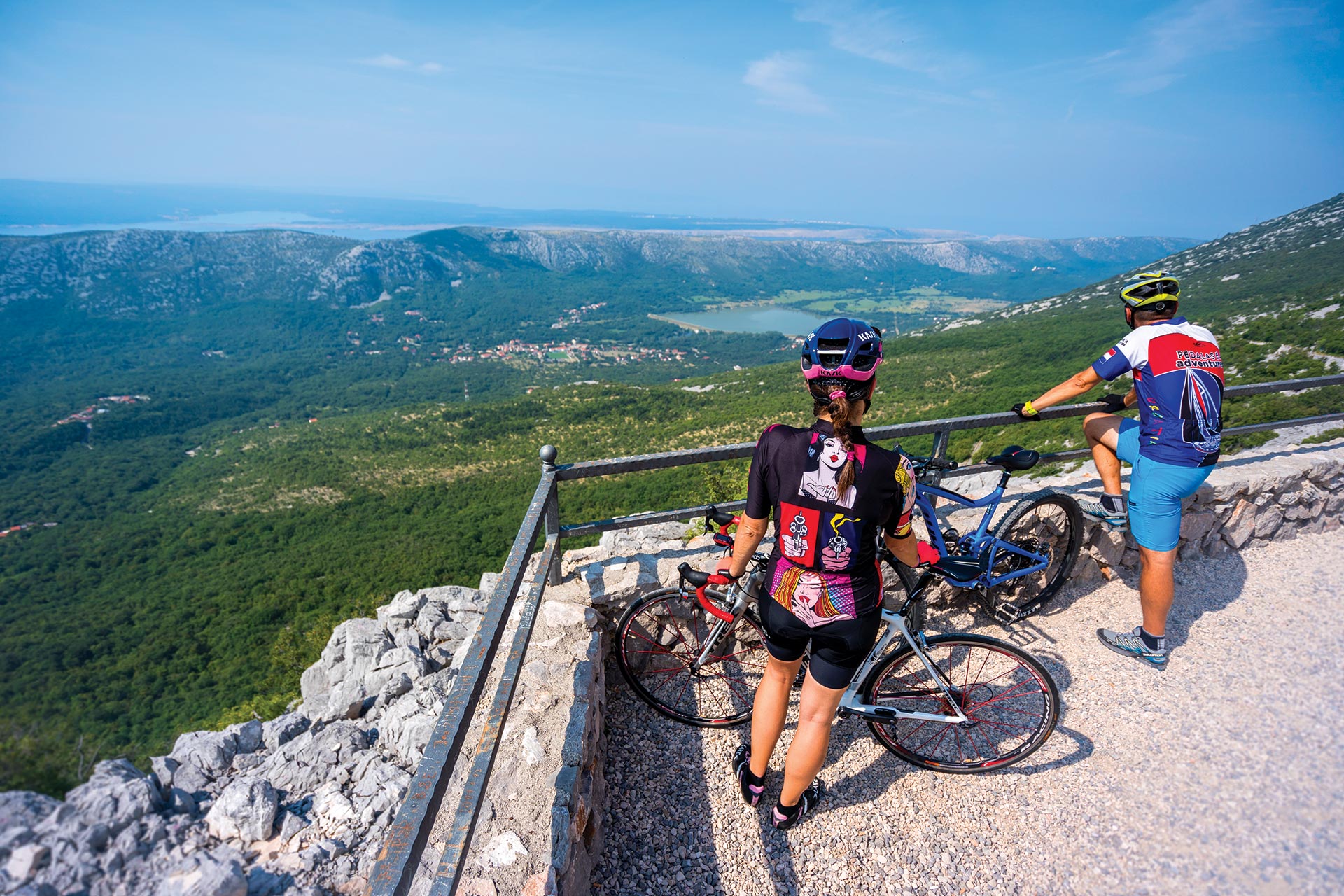
An exceptional geographical position, a mild and pleasant climate that allows sports activities almost all year round, and a network of attractive bike trails make the Crikvenica Riviera an ideal destination for cycling enthusiasts, regardless of whether you are a professional or recreational athlete. The multifaceted nature of the terrain, the diversity of surfaces and the magnificent vistas of Kvarner Bay allow cyclists to enjoy every kilometre of distance and every metre of elevation. Whether you drive past wonderful beaches, picturesque medieval towns, magnificent Frankopan castles, or above the steep cliffs of Vinodol, a bike tour of the riviera is always an enjoyable experience. Road, trekking or mountain bike? It doesn’t matter! Ten attractive, interconnected cycling routes will provide you with an unforgettable adventure on two wheels.
See more about the technical characteristics of the tracks below.
Info:
Crikvenica cycling club
Kotorska 15, Crikvenica
biciklisticki.klub.crikvenica@gmail.com
www.bkc.hr
Licensed cycling guides:
Dragan Malnar
+385 91 531 9511
draganmalnar@gmail.com
Marko Jerković
+385 95 368 5715
jerko_1990@hotmail.com
Aleksandra Domijan
+385 91 240 5678
elbike.crikvenica@gmail.com
www.elbike-crikvenica.com
ROUTE 300
An attractive circular route that connects the most beautiful sections of the coastal part of the Crikvenica-Vinodol Riviera with its picturesque hinterland and rich Frankopan heritage.Starting from the centre of Crikvenica, the route leads along the coastal road to Selce, continues slightly uphill to Bribir, and then follows an attractive climb to the wonderful Eyes of Vinodol viewpoints. Afer a series of shorter climbs and descents offering breathtaking views, there is a longer downhill part via Hreljin, afer which the route returns along Lake Tribalj and the course of the Dubračina to Crikvenica waterfront.
START - END
CRIKVENICA – SELCE – GRIŽANE – ANTOVO – HRELJIN – KRIŽIŠĆE – DRIVENIK – TRIBALJ – CRIKVENICA
Surface: 100% asphalt
| LENGTH: 52 km | ELEVATION GAIN: 1100 m |
| LOWEST POINT: 2 m | HIGEST POINT: 790 m |
| CATEGORY: Road | PHYSICAL CHALLENGE: 3/5 |


ROUTE 301
This route leads from Novi Vinodolski, a town with a rich cultural heritage and long history, to the freshness of the forests of Gorski Kotar, full of fruits of the forest and offering fantastic views of Kvarner’s islands.From Novi Vinodolski, the route leads along the coastal road to Klenovica, where it turns uphill for 10 kilometres to Luka Krmpotska. It then continues in the direction of Lukovo, offering a view of wide clearings, with occasional wild horses. In Lukovo, refresh yourself with dishes based on wild herbs, and then enjoy a light and long downhill section via Bribir and the Pavlomir vineyards back to Novi Vinodolski.
START - END
NOVI VINODOLSKI – POVILE – KLENOVICA – LUKA KRMPOTSKA- PLETENO – LUKOVO – BRIBIR – NOVI VINODOLSKI
Surface: 100% asphalt
| LENGTH: 60 km | ELEVATION GAIN: 1280 m |
| LOWEST POINT: 6 m | HIGEST POINT: 860 m |
| CATEGORY: Road | PHYSICAL CHALLENGE: 3/5 |

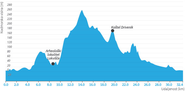
ROUTE 302
This interesting and undemanding circular route is intended for recreational cyclists who want to discover the hidden details of the rich history of the Crikvenica-Vinodol Riviera. From Crikvenica, ride along the coast via Dramalj (Kačjak) to Jadranovo. Stop along the way at Lokvišće archaeological site, which dates back to Roman times and is rich in a natural healing mud with balneological qualities. From Jadranovo, the route leads uphill to the main coastal road, continues to Križišće, and then turns towards Drivenik, where a Frankopan castle keeps watch on the hill. Make sure you have a good look at it! From Drivenik, the route leads through picturesque hamlets around Lake Tribalj and descends to the starting point along the Dubračina stream.
START - END
CRIKVENICA – DRAMALJ – JADRANOVO – KRIŽIŠĆE – DRIVENIK – TRIBALJ – CRIKVENICA
Surface: 75% asphalt, 25% gravel
| LENGTH: 32 km | ELEVATION GAIN: 600 m |
| LOWEST POINT: 2 m | HIGEST POINT: 265 m |
| CATEGORY: Trekking | PHYSICAL CHALLENGE: 3/5 |
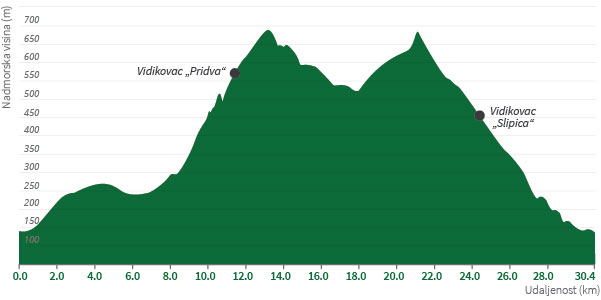
ROUTE 303
The whole of Vinodol is an enchanting area that abounds in rich history, cultural and historical monuments, beautiful landscapes, and interesting traditions.From Bribir, a small town with a turbulent and fascinating history from the time of the Frankopan princes, set off to explore the Vinodol hinterland. A combination of asphalt and gravel roads will take you to the Eyes of Vinodol, a fantastic series of landscaped viewpoints offering unforgettable views, but also to the Frankopan fortifications, a reminder of times gone by, which are ready to reveal untold stories.
START - END
BRIBIR – GRIŽANE – ANTOVO – PRIDVA – SLIPICA – BRIBIR
Surface: 75% asphalt, 25% gravel
| LENGTH: 30 km | ELEVATION GAIN: 780 m |
| LOWEST POINT: 135 m | HIGEST POINT: 690 m |
| CATEGORY: Trekking | PHYSICAL CHALLENGE: 3/5 |
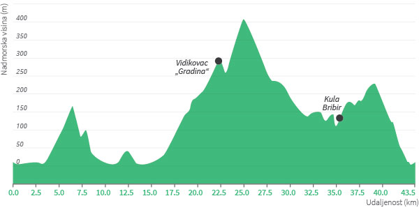
ROUTE 304
The Frankopans, the Princes of Krk, marked more than five centuries of Croatian history, leaving behind a legacy of numerous castles, forts and manors throughout the Kvarner region. The circular trekking route that connects Crikvenica and Novi Vinodolski is ideal for recreational cyclists who would like to explore the Riviera on an MTB or trekking bike. Afer an initial warm-up along the coastal road to Selce, a slight ascent begins towards the hinterland and the vineyards afer which this area is named. Afer a tour of Novi Vinodolski, the route leads uphill to the Gradina viewpoint above Ledenice, and then continues via Bribir along a panoramic gravel road that offers magnificent views all the way to the eastern coast of Krk and the coastal part of the entire Crikvenica-Vinodol Riviera.
START - END
CRIKVENICA – SELCE – NOVI VINODOLSKI – LEDENICE – BRIBIR – ZORIČIĆI – CRIKVENICA
Surface: 90% asphalt, 10% gravel
| LENGTH: 43,5 km | ELEVATION GAIN: 890 m |
| LOWEST POINT: 2 m | HIGEST POINT: 410 m |
| CATEGORY: Trekking | PHYSICAL CHALLENGE: 4/5 |

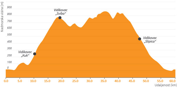
ROUTE 305
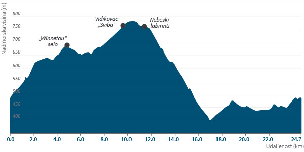
Experience the magic of labyrinths and feel the strong energy woven into the natural environment of the Vinodol hinterland. This easy circular route along a rather undemanding terrain will delight many trekking cyclists. The route starts at Bater, and takes you slightly uphill to the hamlet of Pleteno, which is located on the Winnetou tourist map. Here, you’ll feel the spirit of the Wild West and find yourself in the world of the popular Indian chief. Stop at the Celestial Labyrinths and recharge your batteries, and then take a break while enjoying the Sviba viewpoint.
START - END
BATER – PLETENO – SVIBA – LUKA KRMPOTSKA – DRINAK – BATER
Surface: 65% asphalt, 35% gravel
| LENGTH: 25 km | ELEVATION GAIN: 520 m |
| LOWEST POINT: 400 m | HIGEST POINT: 780 m |
| CATEGORY: Trekking | PHYSICAL CHALLENGE: 2/5 |

ROUTE 306
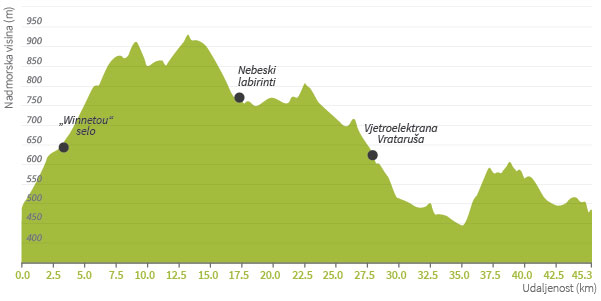
The Celestial Labyrinths provide a magnificent view of the sky, the sea and the islands. Take a deep breath, calm down and bring about change in yourself.If you’re an MTB cyclist of medium technical and physical ability, and want to enjoy the upper part of the Vinodol hinterland with its beautiful panorama of the Kvarner islands, then we recommend this route. Afer an initial ascent, immediately afer the start, there will be a dynamic interchange of terrain and vegetation – from typical Mediterranean low vegetation and green meadows with windmills to dense pine forests. You’ll ride along gravel paths for many kilometres, including a few shorter technically demanding parts.
START - END
BATER – PLETENO – BREZE – LUKA KRMPOTSKA – ALAN – VRATARUŠA – BILE – BATER
Surface: 30% asphalt, 60% gravel, 10% forest path
| LENGTH: 45 km | ELEVATION GAIN: 860 m |
| LOWEST POINT: 440 m | HIGEST POINT: 930 m |
| CATEGORY: MTB | PHYSICAL CHALLENGE: 3/5 |
| TEHNICAL COMPLEXITY: 2/5 |
ROUTE 307
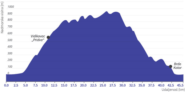
A dynamic and technically demanding MTB route intended for more advanced recreational cyclists and those who want to try out parts of the popular MTB race tracks on the Riviera: the Crikvenica XC Marathon and Fužine2Sea.From the centre of Crikvenica, the route follows the course of the Dubračina in the direction of Tribalj, and then leads uphill along an attractive forest path to Baretići. It continues uphill along the most beautiful mountain road in this area, offering views of Lake Tribalj and the Kvarner archipelago. At Mahavica viewpoint, you enter the realm of Gorski Kotar’s forests and ride to the highest point of the route (950 m). As a reward, there follows a nearly 10-km-long combination of forest and single tracks, which will certainly give you something to remember.
START - END
CRIKVENICA – ANTOVO – MAHAVICA – BARCI – ZORIČIĆI – KOTOR – CRIKVENICA
Surface: 40% asphalt, 30% gravel, 30% forest path
| LENGTH: 45 km | ELEVATION GAIN: 1350 m |
| LOWEST POINT: 2 m | HIGEST POINT: 950 m |
| CATEGORY: MTB | PHYSICAL CHALLENGE: 3/5 |
| TEHNICAL COMPLEXITY: 4/5 |
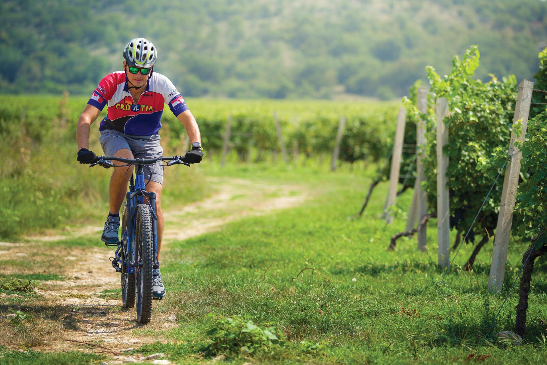
ROUTE 308
This circular route through the hinterland of Vinodol reveals the tastes and aromas of fruits of the forest, leads through a dynamic terrain, and provides a fantastic combination of land and sea.If you’re an MTB cyclist of moderate fitness looking for undemanding terrain, then this route is just for you. As you ride, you’ll explore hidden paths and gravel roads in the freshness of fir and beech forests. This environment will especially appeal to those who enjoy uninhabited areas and pristine nature. Add to this a unique culinary offer and a section of a panoramic road with numerous viewpoints, and it becomes clear that you can’t go wrong if you opt for this route, especially in the summer months.
START - END
LUKOVO – SLIPICA – PRIDVA – LUKOVO
Surface: 15% asphalt, 70% gravel, 15% forest path
| LENGTH: 42 km | ELEVATION GAIN: 860 m |
| LOWEST POINT: 340 m | HIGEST POINT: 880 m |
| CATEGORY: MTB | PHYSICAL CHALLENGE: 3/5 |
| TEHNICAL COMPLEXITY: 3/5 |

ROUTE 309
An interesting circular track intended for recreational MTB cyclists who like a dynamic configuration with a combination of gravel roads, old cart tracks, and single trails. Afer a start in Novi Vinodolski and an initial warm-up along the coast, you’ll have the opportunity to discover some abandoned paths and ride uphill for 7 km from Klenovica to Drinak. This is followed by a gravel section to Batter, an uphill part along a forest path, and a downhill one towards Bribir, with a special emphasis on the descent along an old hiking trail beneath Slipica viewpoint, and another attractive descent along a former mule track.
START - END
NOVI VINODOLSKI – POVILE – KLENOVICA – SMOKVICA KRMPOTSKA – DRINAK – BATER – BRIBIR – NOVI VINODOLSKI
Surface: 30% asphalt, 45% gravel, 25% forest path
| LENGTH: 50 km | ELEVATION GAIN: 1200 m |
| LOWEST POINT: 1 m | HIGEST POINT: 650 m |
| CATEGORY: MTB | PHYSICAL CHALLENGE: 4/5 |
| TEHNICAL COMPLEXITY: 4/5 |